Disaster response planning for Odisha supper cyclone
Client
Baird & Associates, CANADAServices
GIS for cyclone-resilient infrastructure planning, mapping vulnerable areas, and surge protection.October 29, 1999: The Unforgettable Super Cyclone
October 29, 1999, stands etched as a day of devastation in the history of coastal districts of Odisha. A super cyclone, with winds roaring at 270-300 kmph, tore through the region, leaving behind a trail of destruction that shook the very foundations of life in these coastal districts. Torrential rains, waves surging to monstrous heights, and winds that penetrated 200 km inland brought Odisha to its knees.
An Unprecedented Catastrophe: The Aftermath
The numbers speak of a catastrophe that left scars on hearts and landscapes:
Human Lives Lost: 9893 Millions Displaced,Habitats Decimated
Houses Washed Away: 25,956
Houses Fully Collapsed: 7.48 lakh
Livestock Perished: 0.45 million
Crop Area Affected: 1.8 million ha
The super cyclone was an unparalleled disaster, a stark reminder of nature's might. It was in the wake of this catastrophe that SPARC's story of resilience began.
Catalysts of Change: SPARC's Response
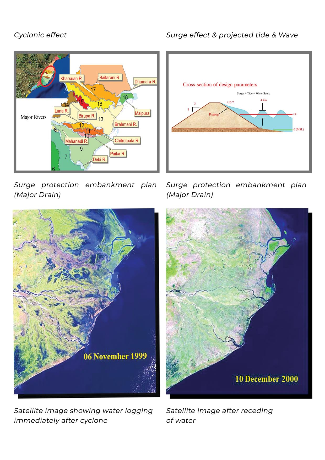
SPARC joined hands with Baird and Associates, a team engaged by the Canadian International Development Agency for damage assessment and cyclone-resilient infrastructure planning. The mission was to map and plan a cyclonic storm surge embankment-cum-coastal highway that would stand as a bulwark against nature's fury.
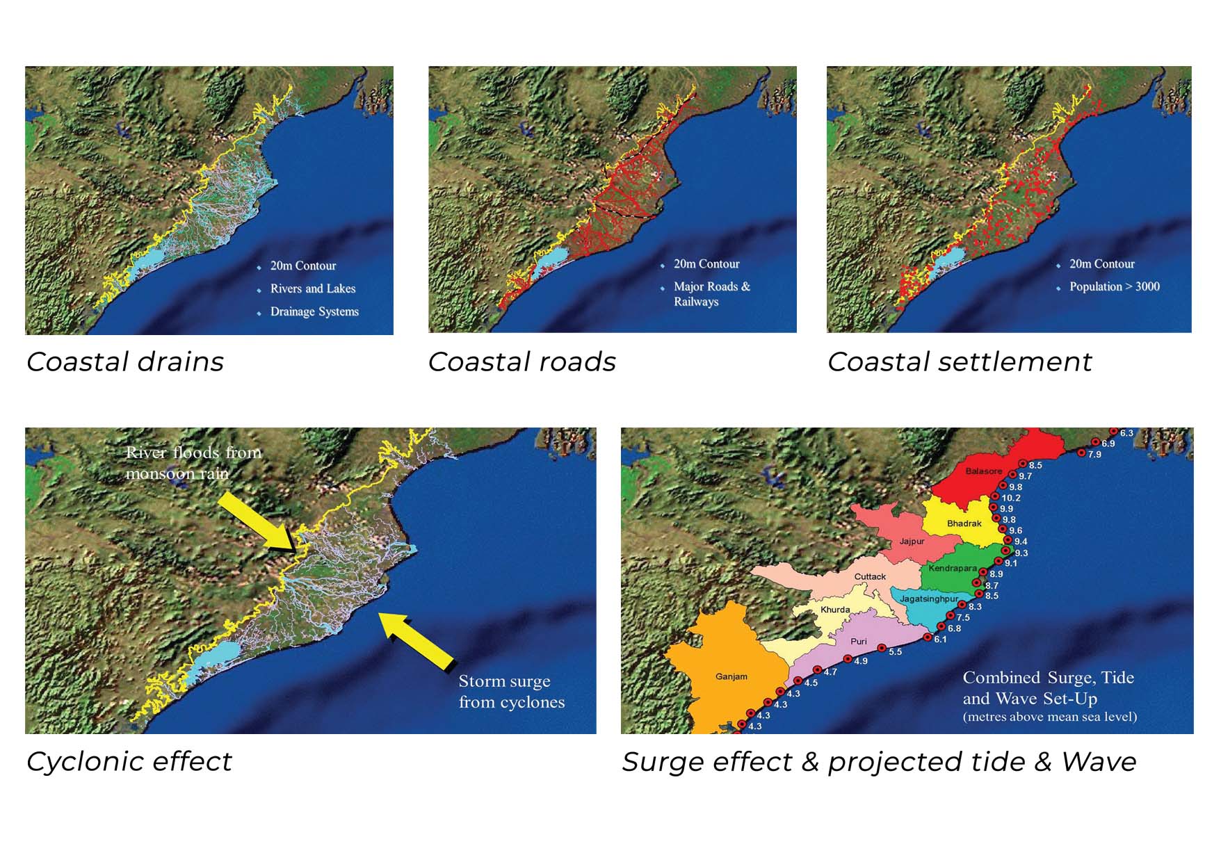
Mapping the Vulnerable: A New Dawn of Resilience
The canvas of SPARC's work was vast – roads, settlements, rivers, and drainage systems, all under the 20 m ground elevation mark. The challenge was to model the probable surge height, an intricate dance of rain and high tide. The SPARC team delved deep, designing surge protection, saline embankments, and river embankments. The focal point was the Doab areas, the land nestled between two mighty rivers.
Empowering Resilience Through GIS
The heart of the transformation lay in Geographic Information Systems (GIS). SPARC's work wasn't just about lines on a map; it was about weaving a tapestry of disaster-resilient infrastructure. GIS provided insights that transcended numbers. It offered a visual representation of disaster risk vulnerability, enabling the effective planning of infrastructure that would stand resolute against the might of future calamities.
A Legacy of Transformation
SPARC's collaboration wasn't just a project; it was a story of resilience, of response, and of forging a better tomorrow. The cyclone response planning was a testament to the power of human innovation and dedication. SPARC's legacy stands as a reminder that amidst the darkest hours, human ingenuity can rise, transforming challenges into opportunities. The cyclone may have left scars, but SPARC's response etched a legacy of resilience and empowerment, a beacon of hope for a future where nature's fury meets human preparedness.