Assessment and monitoring of World's largest slum land rights titling project
Client
Sir Ratan Tata TrustServices
Employed geospatial technology, high-res satellite imagery, DGPS, drones, GIS software, and rule engines for urban slum assessment and land rights allocation.Unprecedented and sporadic growth of the urban slums have been a great challenge for the Governments across the cities. Safety & Security of the population in these slums are major concerns for the government. There have been many schemes and programs implemented by the governments for providing safe habitat to the urban slum population. Govt. of Odisha has been working continuously for improvement of the urban slum population, and have launched one such historic scheme named as “Jaga Mission” to allot land rights to the urban slum populations covering about 400,000 households in 1200 slums across 114 cities/ townships across the state. SPARC has been entrusted with the responsibility of assessment of the household in urban slums through utilization of GIS and Remote Sensing through use of latest technologies. The project has successfully progressed in record time citing exemplary achievements through efficient use of information technologies and has also proved the technical prowess capacity and capability of the professionals involved in the project.
Technology & methods used:
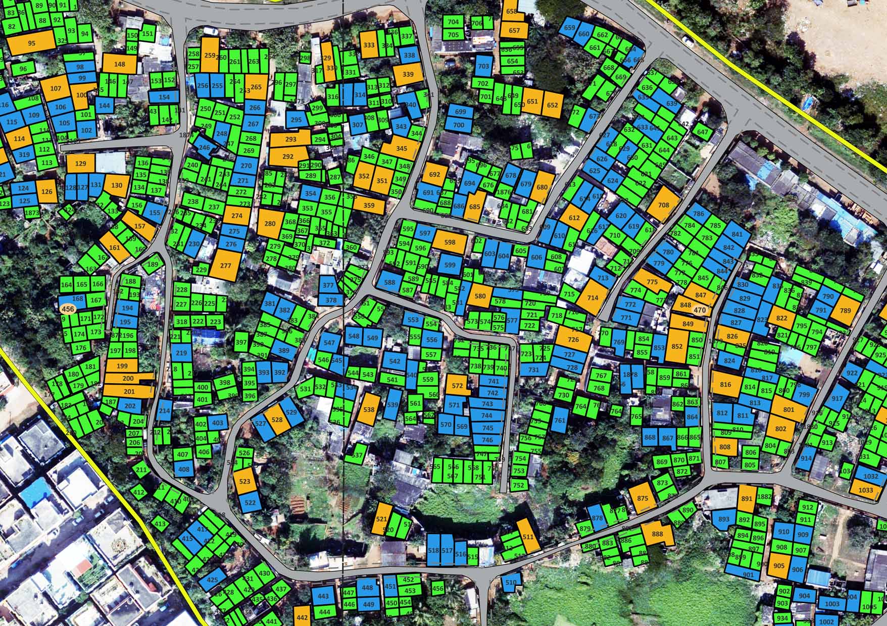
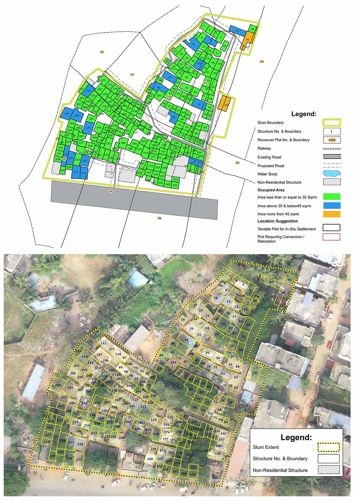
The project planning has been carried out using the High-Resolution Satellite Images (HRSI) to identify the urban slum areas within the cities and townships. Differential GPS-based Ground Control Points (GCPs) have been carried out with reference to the state control points maintained by the Odisha Space Application Center (ORSAC) using the high precision DGPS instruments. Aerial survey of the identified slums within the respective cities/ townships were carried out using the Drones to capture very high resolution aerial images of the slums. The high-density images captured in the process were subjected to image integration and georeferencing procedures with reference to the surveyed GCP control points using high performance computing workstations and relevant processing softwares.
The GIS software tools were used to identify and delineate the urban household within the slums and to accurately measure the land area taken by the individual households. Business process algorithms were used to process the identified households to ascertain whether the land occupied by the households are legitimate as per the rule for the specific townships. A complex rule engine has been developed to include the government's land allocation policies. With application of the rule-engine on the household information detailed categories of the household there entitlements, tenability status, area to be allocated/ revoked are computed and presented for approval of the authorities for subsequent issue of the Land Rights.
Upon completion of the survey, eligible slum residents receive a certificate of land ownership in the name of the female head of the household, promoting gender equality and empowerment. The Jaga Mission also encourages community involvement through Community Resource Persons (CRPs) who engage with the community, raise awareness, and support data collection and beneficiary identification.
The Jaga Mission has brought in several benefits to the slum dwellers, providing them with a sense of security and stability as they gain ownership rights over their dwellings' land. The certificate of land ownership also serves as proof of identity, enabling access to government services and programs, benefiting marginalized communities in particular. Formalizing informal settlements through land ownership contributes to improved urban planning and infrastructure development, fostering inclusive and sustainable urban development in Odisha.
Conclusion:
Jaga Mission, in association with SPARC as the technology partner has made significant impact in empowering slum dwellers, promoting equitable land rights, and fostering sustainable urban development in Odisha. Geospatial technology played a vital role in this mission, enabling accurate mapping and data-driven insights for effective slum management and resource allocation, ultimately leading to a brighter future in Odisha.