Odisha is home to about 2000 Asiatic elephants. Good forest cover and favourable terrain conditions provide essential habitats for these majestic animals. The state has taken proactive steps to conserve elephants and their habitats through elephant reserves and designated corridors, which facilitate the movement of elephants between different forest areas. However, these elephants often stray into nearby human settlements giving rise to human-elephant conflicts such as damage to property/ crops, human causalities and harm to elephants.
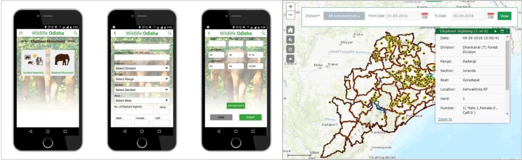
SPARC has developed and implemented an innovative GeoICT platform (WebGIS and Location based mobile applications) for Chief Wildlife Warden, Odisha for tracking and monitoring of elephant movements across the state.
This innovative solution not only provides critical insights into elephant behaviour and habitat utilisation but also engages local communities in real-time conservation efforts. As we delve into the intricacies of this inventive project, we uncover how SPARC's solution is redefining the landscape of elephant conservation and fostering a harmonious coexistence between these magnificent creatures and the communities that share their land.
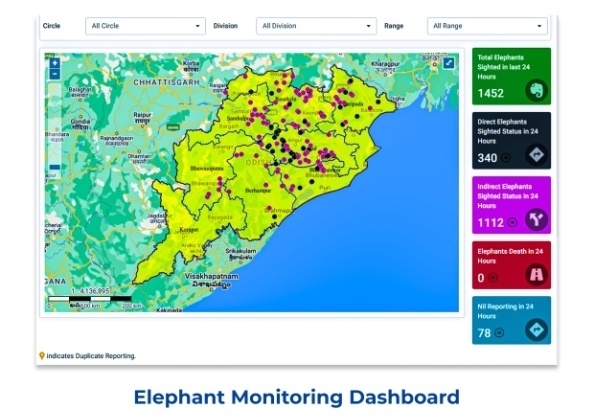
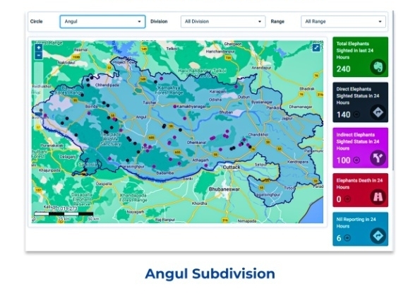
Real-time Tracking: 1000+ wildlife managers across the State use SPARC’s GeoICT Solution to record elephant sighting using mobile app with geo-tagged photographs on day-to-day basis. Such sighting data gets transmitted to a centralised Web GIS system for visualisation and analysis of elephant movement across the State on a near real-time basis and helps understand seasonal elephant movement patterns, their preferred habitat, tracking of herds, etc.
Precise Habitat Mapping: The Tech platform generates accurate habitat maps, aiding formulation of effective elephant conservation land management strategies.
Wildlife Corridors: It also assists in delineating correct elephant corridors and plan for appropriate conservation measures while implementing developmental program.
Spatial Insight: The sighting data are overlaid on hazardous areas such as high-tension power lines, railway tracks, major roads and settlements for possible threat to the elephants and local communities. This helps conservationists make informed decisions.
Citizen Alert System: People living in and around elephant movement areas register themselves using the citizen Mobile App module. The app provides users to Choose preferred language (Odia/ English), Enter Name, address, phone, email (optional), etc. Registered Users can Report elephant movement in their locality in any multiple reporting format as per convenience (photo / video / text/ voice) including location of sighting. Once sighting is registered it is verified by the control room and notification is broadcasted to all registered mobiles in the 5km radius of the reported location.
Conflict Zone Identification: Location-based elephant movement data provides critical insight to understand elephant behaviour and helps wildlife managers in elephant protection and reducing man-elephant conflicts.
Informed Decision-Making: Complex ecological data provided by us also helped wildlife conservationists in aiding conservation planning and policy formulation.
Effective Interventions: Our GIS data helped in targeted interventions which maximised the impact of conservation initiatives. Together it ensured the survival and flourishing of these magnificent creatures.
SPARC’s innovative solution has helped in design and implementation of sustainable conservation measures, reduce man-elephant conflicts, improve community engagements and awareness about the importance of these animals, which are essential for long-term survival these majestic species in the region.