Geospatial Services
We drive informed decisions and optimize operations by offering geospatial analysis, mapping, and visual solutions from urban planning to environmental monitoring.
GIS application development
Web | Cloud | Mobile
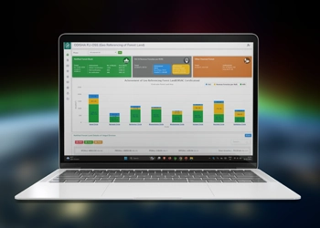
We specialize in web, mobile, and cloud-based services by creating robust and user-friendly applications that leverage geospatial data to solve complex problems. With a focus on innovation and efficiency, we offer customized services tailored to your needs, empowering your business and institution with informed decision-making and spatial analysis capabilities.
GIS mapping and geodatabase development
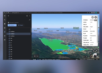
We create sophisticated mapping applications with advanced geospatial analysis capabilities and deliver tailored services across sectors like urban planning, environmental management, and transportation. With a focus on accuracy and innovation, we empower you to make informed decisions and improve operational efficiency using location-based data insights.
Remote Sensing & Photogrammetry

We expertise in satellite and aerial imagery analysis which enables us to provide you with valuable insights for environmental monitoring, land use classification and disaster assessment. Our accurate and detailed solutions aid you in informed decision-making, resource management and sustainable development, addressing global challenges and driving positive change.
Location Information Systems

We offer comprehensive solutions for businesses and government agencies to leverage location-based data. With our expertise in GIS, GPS and mapping technologies, we deliver accurate location intelligence. Our tailored solutions optimize your operations, improve logistics, and enable you with informed decision-making across diverse industries, driving strategic advantage and growth.
AI/ML based Image processing
We are revolutionizing image analysis through advanced algorithms and models. Our services encompass object detection, recognition, segmentation, and enhancement across diverse applications, from medical imaging to autonomous vehicles. With cutting-edge techniques, we deliver accurate real-time results, empowering you to harness visual data for efficiency and growth.
Spatial Data Engineering

We offer comprehensive solutions for managing, analyzing and visualizing geospatial data. We specialize in spatial data processing, GIS software development and database management. From cartographic design to 3D modeling and spatial analysis, our tailored services enable you to make informed decisions, optimize workflows and gain valuable insights from location-based data.
Differential GPS Surveys

We offer high-precision positioning services for diverse applications. With experienced surveyors and advanced DGPS technology, we ensure centimeter-level accuracy for land surveying, construction site mapping, and infrastructure planning. Our real-time kinematic (RTK) solutions deliver instant and reliable results, enabling you to optimize projects and reduce costs.
